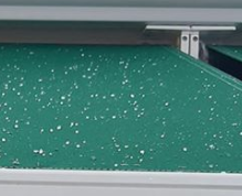
Snow Palmela january
 2020-01-21 (Susana Freitas)
Snow in Palmela? What happened on January 20, 2020?
The occurrence of snow in Palmela region (Peninsula of Setubal in the west coast of Portugal) on the morning of January 20, 2020 has been documented on several social media platforms.
Most of the Continental Portuguese territory had clear or partly cloudy skies on January 20th. However, between 8 and 11am local time, the Setubal Peninsula was affected my medium level cloudiness organized within an upper-level trough, that caused light rain. This precipitation was observed in radar imagery. The automatic weather stations in the area recorded 0.1 mm of rain between 9 and 10am, local time.
The air temperature registered by IPMA’s station in Setubal (at 35 m altitude) was 7.0°C at 8am local time. That temperature decreased to 6.6°C at 10am local time, during the period of increased cloudiness and occurrence of light precipitation. Since the maximum altitude in the Palmela region is 378 m, and considering that numerical modelling data are compatible with a vertical decrease in temperature of 1°C per 100 m, it is possible that the air temperature has reached values close or below 5°C in the region during that morning.
Based on the reports and videos that we were able to analyze, this precipitation episode is likely to have been graupel (also known as snow pellets or tapioca snow). It is a type of hydrometeor characterized by spherical appearance, sometimes conical, usually whitish and opaque. It results from the collision, at altitude, between snow crystals and liquid water at negative temperature, which results in immediate freezing of water on the snow crystals. It corresponds to a cluster of snow crystals surrounded by ice, hence the aforementioned whitish and opaque aspect of its interior.
On the other hand, snow is precipitation of isolated or clusters of ice crystals that fall from a cloud and reach the ground. It is known that snowfall can happen with slightly positive air temperature at levels close to the ground. This is even more pronounced in the case of graupel which, given its characteristics, melts more slowly than snow, and can be observed with air temperatures clearly above 0⁰C.
This means that the occurrence of hydrometeors in solid form does not depend exclusively on air temperature , but also on its structure and other characteristics of the environment related to humidity and wind.
According to a study carried out in 2011 with data from weather stations in mainland Portugal in the period between 1941 and 2009, it was identified that 99.3% of snow cases occurred with air temperature values between -7°C and +5°C, with half of the episodes happening between -1°C and +1°C. Another study in the United Kingdom suggests a 10% probability of snow occurring with an air temperature of 4°C.
However, as mentioned, snowfall is not likely to correspond to the episode observed in Palmela on January 20, 2020.
In order to better characterize the present situation, all users of IPMA meteorological information are invited to share reports related to this event through the address https://observar.ipma.pt/ (or through “OBSERVAR” in www.ipma.pt or through IPMA APP in “ENVIAR OBSERVAÇÃO”).
The shared information should include the location, the time, the type of precipitation observed and, if available, the air temperature, with as much detail as possible.
If there are movies of the event, those should be sent to the address info@ipma.pt.
Imagens associadas


